ADEPT 5.2 is the second major update for ADEPT 5 - a full rewrite of the Adept application using our latest approaches. This new platform will better support delivery of modern, advanced features and can serve mariners into the era of S-100. For example, the NavArea Warnings service in ADEPT 5 is much improved.
Currently the main foundations of the application are laid down and we are filling out vital features, fixing problems and taking on board feedback.
Major improvements in 5.x
- Chart pre-install. Apply AVCS DVDs and the application will cache charts to reduce download bandwidth as and when the vessel obtains licences for those charts.
- Chart install is much faster which allows the application to cope with large portfolios.
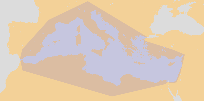
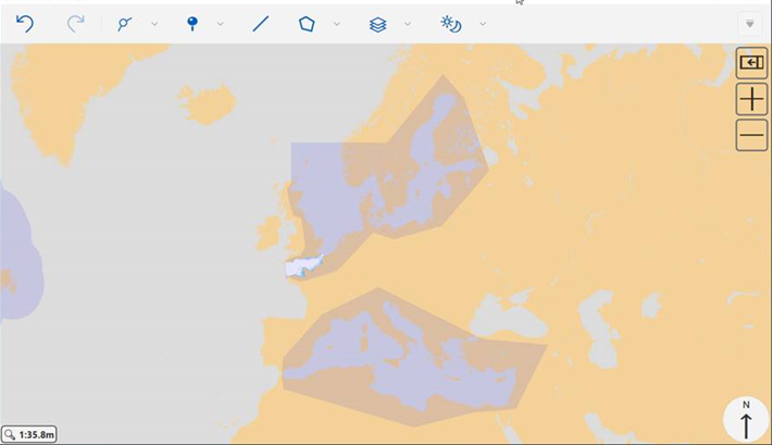
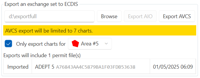
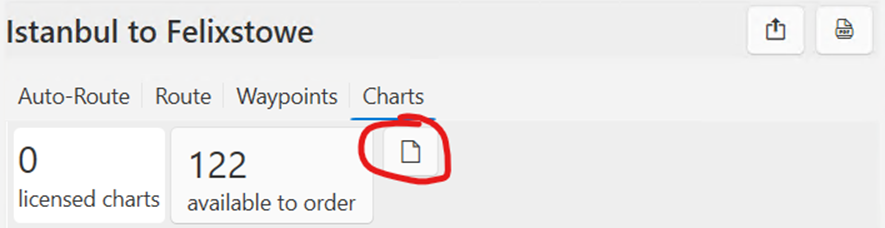
- Export charts limited to a route or area.
- Able to support the needs of PAYS vessels.
- Ordering – single basket and includes ADP area ordering.
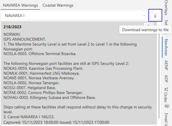
- NavArea warnings – geographic display and much more regular updates.
- New approach to Email Updating where vessel makes a request email containing details of how up-to-date the vessel is in order to get a tailored response that gets the vessel up to date. This will replace the old “push” approach to email updates which will be phased out as installations of Adept4 are superseded by Adept5.
- When a route intersects with AENP sailing directions, links to specific chapters are provided.
Major omissions in 5.x v 4.x
Some features from 4.x are not yet implemented in the new application.
- Display of TotalTide graphs in the application.
- Weather Sea Ice
Change log
V5.2.0.61966
- Coverage of Mediterranean ECA Zone in MARPOL Annex VI layer has been updated
V5.2.0.59163
Mediterranean ECA Zone is now displayed as part of the MARPOL Annex VI layer
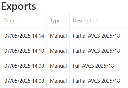
Update to chart exporting to make it more obvious if only a partial export is taking place.
Fixed an issue where negative coordinate values were not being saved correctly when exporting .rut routes
V5.2.0.49907
- Added storm display layer

- Updated fleet tracking to make onboarding process more streamlined
- Fixed an issue where chart update would show as 0KB instead of tick
- Fixed an issue where longitude was not shown on route plan templates when using certain language settings
V5.2.0.47936
Main features
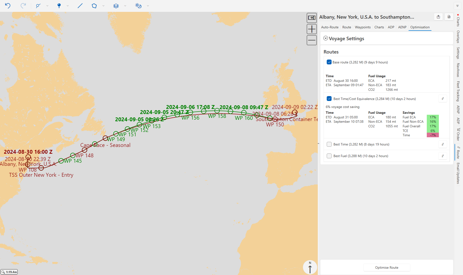
Route optimisation
- Optimisation requests are submitted online with calculations taking place in the cloud
- The Application will monitor optimisation progress and offer option to download optimised routes when calculations are complete
- The application can be used normally during this time and can even be closed
- Optimisations can be fine tuned to defined areas
- Optimised routes are displayed in green on the map to help differentiate them
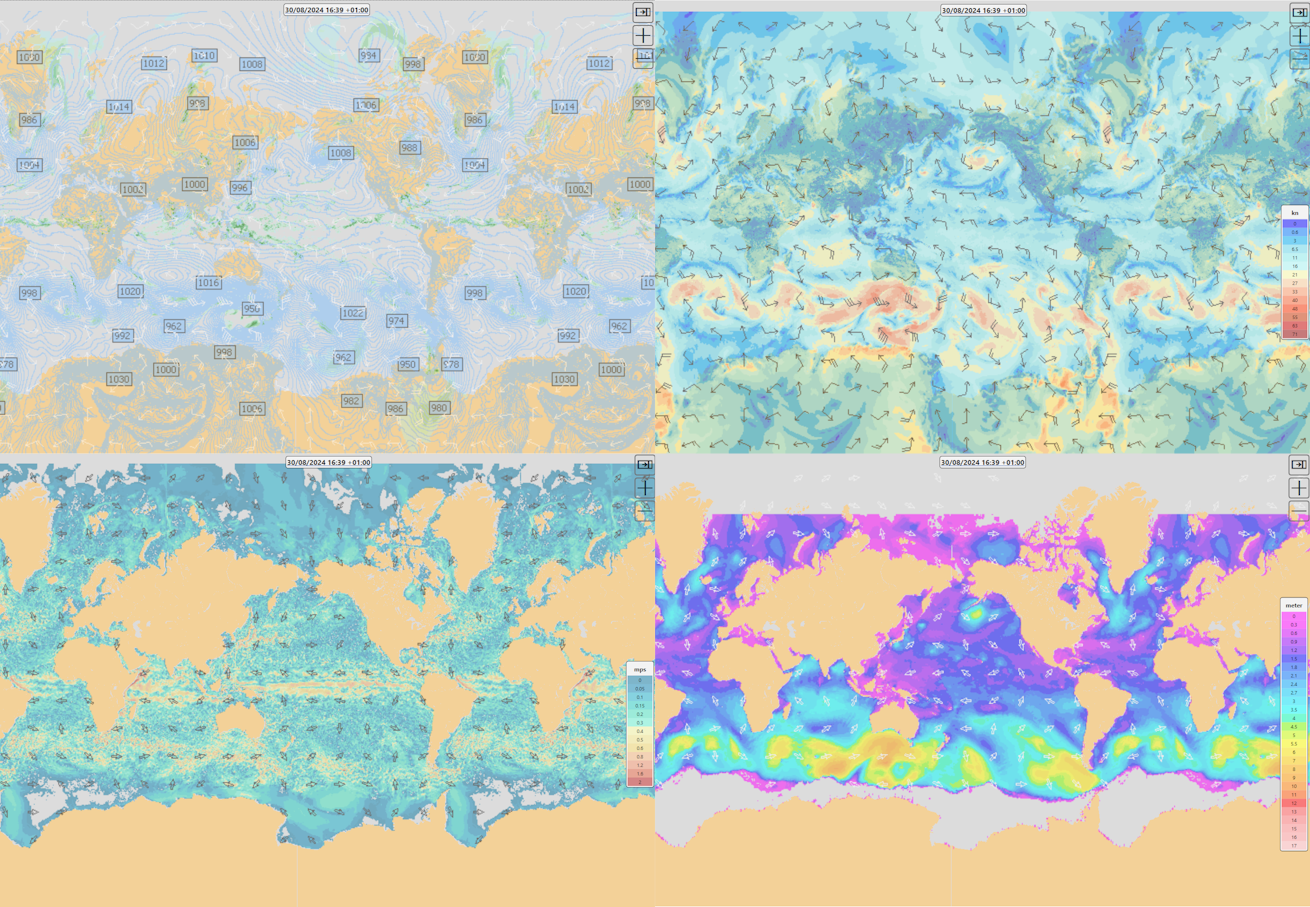
Weather display
- Online weather feed negating the need to download large amounts of data
- Data is automatically cached in the application while it remains valid
- Wind, Ocean Currents, Wave Height & Wind/Pressure/Precipitation layers are available
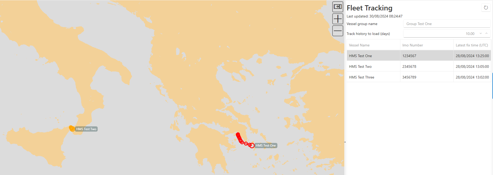
Fleet tracking
- View past tracks along with heading and speed information
- View current positions of vessels
Enhancements
- PAYS : Partial permit is now generated when exporting charts for a route
- Option to show more names on ENC display
- New menu layout with headings
- Ability to use ships own AIS messages for positions, where GPS is not available
- Added link to view status of any current orders
- Allow ADLL dialog to be opened from context menu when selecting valid light on ENC
- Show ADRS radio stations and allow dialog to be opened from context menu
- Deleting a waypoint now renumbers those remaining
- Allow Lat/Lon of waypoint positions to be displayed in degrees in passage plan
- Added paper chart catalogue to backup/restore
- Allow owned AENP to be downloaded regardless of for sale status
v5.1.0.40383
- Fixed 'Not supported' error being shown when overviewing some routes
v5.1.0.39724
- Added support for .rta and .rtn route formats
- Fixed an issue that could occur importing the paper chart catalogue from an email update
- Fixed an issue that resulted in a blank AENP tab being shown when activating second machine
v5.1.0.36845
- Updated parsing of RMC NMEA sentence to still use position information if course value is missing
- Fixed a crash that could occur when using the pick report on ENCs that are missing auxiliary files. This affects charts C1513641 and C1513379 in AVCS WK03/24.
- Prevented the application from closing while important operations (eg chart updating) are in progress
v5.1.0.36344
- Fixed receiving NMEA positions from GNSS sources other than GPS
- Fixed an issue where part of the layers menu was not visible on smaller displays
- Fixed a crash that could occur when listing or ordering charts for a route
- Fixed a crash that could occur when ordering charts if the application only had a basic catalogue available (installed from DVD rather than updated online)
- Fixed a crash that could occur if AENP permits were unreadable
- Fixed a crash that could occur when cancelling a backup/restore operation
v5.1.0.35019
Main features
- Integration with ADP
- See RS1345, RS6 and TotalTide information on the chart
- Get tide height predictions along the route
- Update ADP data online from within the application
- Support for ADMIRALTY Standard Nautical Charts (paper charts)
- Catalogue display
- Export order to ADC basket file
Enhancements
- Added ability to download NAVAREA warnings to text file
- Added option to expand different sections of the order basket to view items more clearly
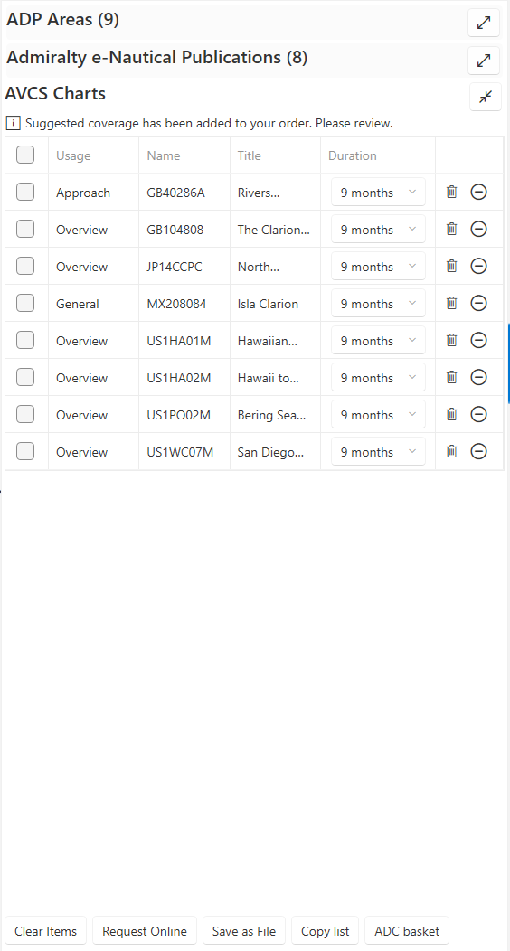
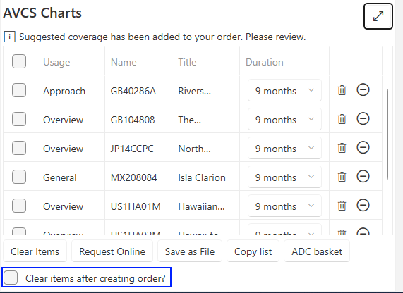
- Added option to clear order basket once the order has been submitted / order file created
- Added option to export route to a file with all associated route plan metadata (.csroute)
- Changed default ENC license length to 6 months
- Updated auto-route database
Fixes
- Fixed crash when USB drive was removed from machine while a file dialog was open
- Fixed crash when a route had an invalid waypoint name
- Fixed crash that could occur when copying contents of an order basket
- Fixed crash that could occur when deleting a waypoint from a route via keyboard
- Fixed crash that could occur when importing a route file
- Fixed unexpected behaviour when removing multiple selected AVCS charts from order basket
- AENP email updating now handles missing files correctly
- False values will now show an empty checkbox in the generated route plan report instead of a blank space
v5.0.1.32741
- Fixed an issue where empty routes could be migrated from version 4 of the application and causes problems in version 5
v5.0.1.31370
- Fixed an issue where ADC baskets exported from the application could not always be imported into the backend website/ADMIRALTY Digital catalogue
v5.0.1.30923
Route plan document improvements
- Users can now select which template is used when generating the route plan report. This is done via the settings pane
- Custom labels / headers can now be defined for template fields
Email updating
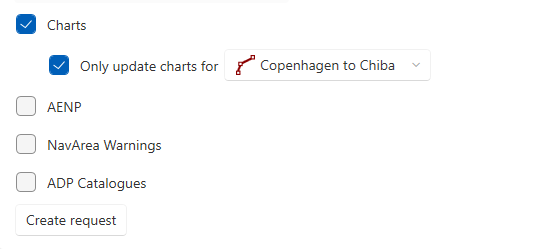
A Route or Area can now be selected when generating an email update request. This is to allow PAYS customers to scope their updates, thus reducing download sizes.
v5.0.1.30603
- Route plan document improvements
- Users can choose where the file will be saved.
- Fixed an issue where some custom fields were not visible in the application.
- Fixed copy and paste to and from document fields.
- Fixed an issue where charts could not be updated in certain locales.
- Fixed an issue where installation was allowed to proceed if only the .NET 7 runtime was installed (.NET 6 is required)
- Fixed an issue where some AVCS functionality was still available if holdings management was suppressed.
v5.0.1.30190
Route plan document export
Added capability to export a PDF route plan document via the Route Overview.
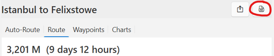
A template editor application (supplied separately) allows distributors and end-users to control the content and layout of the generated document.
Improved NMEA support
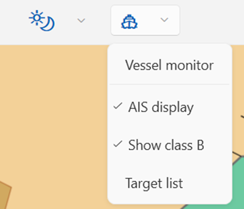
Added capability to display AIS aids to navigation and calculate point of closest approach to AIS targets.
Added route monitoring functionality (Overlays pane -> Follow route). For this option to be available, the application must be receiving GPS positions and the vessel must be near the route.
Adept5 receives NMEA sentences over a local network (via UDP), either from a dedicated ‘pilot plug’ style hardware device or broadcasted from the NMEA Service software (supplied separately).
Backup/restore
Added backup/restore functionality to the Settings tab.
Chart holding report
It is now possible to create a holding report PDF for a particular route or area (via the Route overview or Charts in area tabs)
Route editing
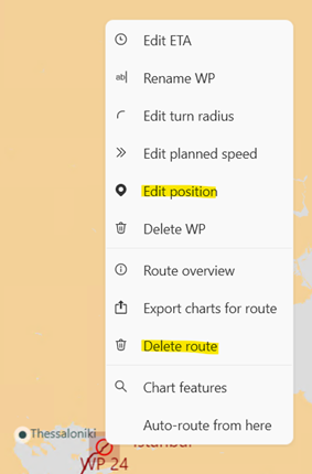
- Added capability to directly edit the latitude/longitude of a point or waypoint by right-clicking it on the chart and selecting Edit position.
- It is now possible to delete a route directly from the chart by right-clicking it and selecting Delete route.
Fixes
- Fixed an issue where the application could crash when reordering charts if AIO was due for renewal.
- Fixed an issue causing slow drawing performance for certain charts.
- Fixed an issue where the ‘refresh charts’ button was not enabled when no permits were installed.
- Fixed an issue where copying text to the clipboard could crash the application.
v5.0.1.27925
Improved error handling for serious errors
In the event of an error which forces the application to close, an improved exception dialog will appear, which also provides the option to send an error report directly to the developers via the internet. This will assist us in rapidly diagnosing and fixing any issues.
Auto-routing fix
Fixed a rare crash that could occur at startup on very out-of-date operating systems.
Experimental NMEA support (GPS and AIS)
The application is now able to receive NMEA sentences over a local network (via UDP), either from a dedicated ‘pilot plug’ style hardware device or broadcasted from the NMEA Service application (supplied separately).
In contrast to Adept 4, the application cannot read NMEA directly from a serial port; the NMEA Service now provides this capability.
The application can
- display own ship’s position on the chart based on GPS NMEA sentences
- display AIS class A and B targets on the chart
- display a list of AIS targets including bearing and range from the own ship
The application cannot yet
- do approach point calculations to determine which targets present a collision risk
- fully display AIS aids to navigation
- update the own ship’s position from
!AIVDOsentences
v5.0.1.27127
Route planning - Waypoints
User can select UTC offset when entering a waypoint ETA/ETD.
ETAs (in system time) are now shown for zone intersections in the waypoints list.
Activation
Fixed an issue that could prevent the application from being activated on certain machines.
Auto-Route from user-selected position
Fixed an issue that prevented creating an Auto-Route from a point.
User interface improvements
Improved order page layout.
v5.0.1.27001
Open AENP at specific chapter
When the route passes through an AENP chapter, a link in the waypoint list allows the book to be opened directly at the correct chapter.
Chart updating
The ‘update all charts’ button is now disabled until catalogues and permits have been downloaded.
After updating, users will now be prompted to export charts.
Preinstall improvements
The application now performs better when a large number of charts are pre-installed.
Route overview
Fixed an issue where no information was initially visible when opening a route overview.
List of Charts for Area
The number of items available to order now correctly excludes AIO.
Activation
Fixed an issue that could prevent the application from being activated on certain machines.
Route import
Route files can now be dragged and dropped onto the application.